Diablo Lake to Park Creek
Our backpacking trip was to be a Cascades traverse, starting at Diablo Lake on the west side, going up and over the divide at Park Creek Pass, and then down the east side of the range into the town of Stehekin at the head of Lake Chelan. It was a trip we'd been talking about doing for years, so we were really excited about it. There was just one hitch: there's no public transportation that far into the mountains on the North Cascades Highway. Anne's mom was going to be picking us up in Chelan at the end of the trip, and we were then going to fly home from Wenatchee, so we didn't have a car and needed to find a creative way to get to the trailhead. We spent some of each of our first few days in Seattle trying to puzzle out how to get there, with none of the options looking too favorable. One option was to take the train or a bus to Mt. Vernon, then take a local bus as far as Concrete, which was still 30 miles shy of the trailhead. We could find no evidence of a shuttle service, although in our investigations we did get someone from the Marblemount chamber of commerce to offer us a lift for a small fee. Further complicating matters, the local bus, as local buses in rural areas tend to do, only ran twice a day, further limiting our options. Roger was a champ and volunteered to take us, but I was hoping to avoid this option. It was enough that he'd put us up for four days without also asking him to take a six hour round trip taxi drive. In the midst of this, John O'Brien, former co-worker of Roger and Tad and a hiking superhero, arrived. I'd hung out with Johno a couple times before, but hadn't seen him since Tad and Chloe's wedding. But when he heard our plan and the difficulties we were having arranging a trip to the trailhead, he volunteered to take us because he was looking for an excuse to get out and do some hiking himself. All he asked in return was that we pay his gas money, which was a trivial price compared to the thought of sitting in the Cascade Mall in Mt. Vernon for 4 hours waiting for a bus. So on Sunday morning, we blearily answered the door at 7:00 to Johno coming to take us away to the mountains. We bade farewell to our hosts, who had somehow managed to drag themselves out of bed to see us off, and headed north.
Day 1: Colonial Creek campground to Tricouni Camp. 7.7 miles
The drive was nice, and because of the relatively early hour, there wasn't much traffic. After a brief stop at the ranger station to get our permit, we headed for the campground. Diablo Lake is part of a large hydroelectric project owned by the city of Seattle. The first half of our hike would be spent following Thunder Creek from the lake and into the mountains to its headwaters below Park Creek Pass. Our hike started at the Colonial Creek campground on an arm of Diablo Lake where Thunder Creek empties into the lake. After we thanked him profusely, Johno headed for his day-hiking spot a little way back down the highway toward Seattle. We put on our packs, worrying about the fact that they already felt a little heavy, and headed up the trail around 11:00.
The first part of the trail was a relatively gentle
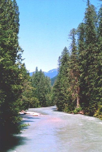 grade through the trees along the shore of lake. Because it was a Sunday, we passed a number of groups heading back out. Eventually we passed beyond the edge of the lake and came to a point where the creek was free-flowing. Shortly thereafter, we crossed the creek on an impressive bridge that looked almost big enough to support a car. I do a lot of backpacking in wilderness areas, so I'm always a little surprised to see the extent of the infrastructure that the Park Service installs. The bridge was definitely necessary, though. Although it was called Thunder "Creek," it would definitely be called a river if it were in California. We stopped for a lunch of salami and cheese at the base of the bridge on the far side.
The rest of the afternoon was a steady climb through forest accompanied by the roar of the creek. After a little while, the trail veered uphill and away from the creek and into a slightly swampy, forested area. As the afternoon wore on, the five and a half hours of sleep we'd gotten the night before were beginning to catch up to us, so were very relieved when we came upon Fisher Creek, which marked the location of our first campsite. The camp was relatively well-developed, with a pit toilet (open air, but with a wooden seat) and even a fire ring. That night's dinner was pasta with a mix from a box. We had to eat it that night because it used a fresh tomato that we didn't think would fare too well the rest of the trip. We were pretty worn out from the day, and we turned in before the sun had gone down.
Day 2: Tricouni Camp to Thunder Basin. 8.9 miles
The next morning, we were a little surprised when we woke up and realized we'd slept for 10 hours. Apparently the hike had taken more out of us than we'd realized. It took us a while to strike camp, so we weren't back on the trail until almost mid-morning. Our morning pace would get better throughout the trip, but the truth is, neither Anne nor I is a morning person, so we never made it out of camp before about 9:30. The hike started with an immediate climb for about a mile to a junction with another trail. Just before the junction, we saw a couple of hikers on their way out. One of them said to me as they approached "We were beginning the think that we had the whole park to ourselves!" We chatted for a little bit then headed on our way. They were the last people we would see until the afternoon of day 4.
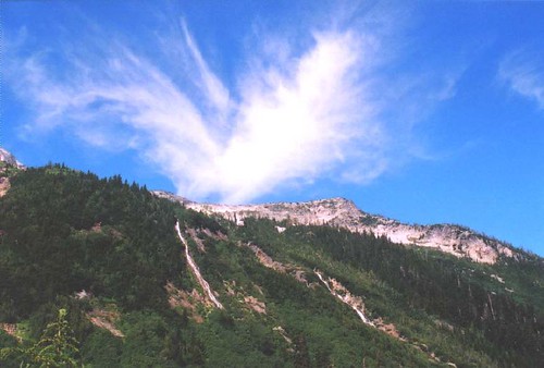
 After a quick snack at the junction, we were disappointed to lose almost all of the elevation we'd struggled to gain that morning. We had to keep reminding ourselves that the whole point of the climb was to skirt around "The Great Dismal Swamp" in the valley below. The name brought to mid mosquitoes the size of sparrows, and although we chafed at having to head back downhill, we were happy to have avoided that. We were rewarded on this stretch of trail with some of the nicest views yet, including some views up Skagit Queen Creek to the Boston Glacier, one of the biggest in the lower 48.
 By mid-afternoon, we had rejoined the creek. We stopped to fill our water bottles and take a quick break, then climbed steadily for the next couple of miles. After a little over a mile of interminable switchbacks, we reached the hanging valley of Thunder Basin. At this end, the valley was still pretty forested, with occasional patches of meadow. However, these meadows were where we started to see a lot of evidence of bears. There were frequently fresh scats on the trail, and some evidence bear beds adjacent to the trail in the meadows. We had been warned that there was high bear activity in the basin, so we were a bit wary. We tried to make more noise, and I think we managed to scare off all of the bears with our heartfelt selections from the Smiths' catalogue.
After about a mile of trekking through the valley, we were beginning to get a bit tired. The long hike was starting to take it's toll, especially compounded by the mosquitoes, occasional patches of stinging nettles (this was of course the one day we had both worn shorts), and the energy required to belt out "Girlfriend in a Coma" for the fourth time. We reached a campsite at around 7:00, and although our permit said we were planning on staying at the high camp 1.2 miles further up the trail, we knew it would be exhausting, and unsafe, to try to press on. So we made our camp there. The campsite itself, like much of this part of the trail, had clearly not seen a trail crew this season. After scrambling over some logs, we found a nice open spot with easy access to the creek and a nice spot to hang a bear bag, which seemed even more necessary than usual this evening. The campsite also held a mysterious metal box, about the size of a chest freezer. At first we thought it was a bear locker, but it was padlocked shut, so it didn't seem too useful. Whatever it was, a bear or a large rock had had its way with the lid, leaving a huge dent. Our poor avocado was also not in very good shape, but it still tasted delicious in our bean burritos. We were in bed almost immediately after dinner.
Day 3: Thunder Basin Stock Camp to 5-Mile Camp. 5.1 miles
After another 10-hour sleep, we rolled our of camp about the same time as the day before (although we struck camp a little more quickly; we'd just slept later). We spent the rest of the morning hiking up the valley. The night before, we'd gotten our first look at the pass we were to cross. We'd been warned by the ranger that there might be snow still on it, although after spending all week roasting in Seattle, it was hard to imagine how. It looked pretty clear from our vantage point the day before, but we did get a bit nervous when we came across a small patch of snow shortly after leaving camp. The rest of the way was clear, however, and it had turned into a beautiful day, hiking through open meadows as the patches of trees got smaller and smaller the further up we went.
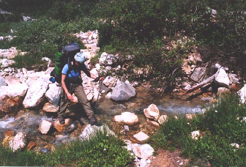 We reached the high camp in time for a mid-morning snack, certain we never would have made it there the night before. We were now looking at the last big climb of the trip, where we would gain 1700 feet in about a mile to reach the pass. The climb itself turned out to be not so bad, as we switched back repeatedly over the creek. The creek was so much smaller at this point that you could almost step across it.
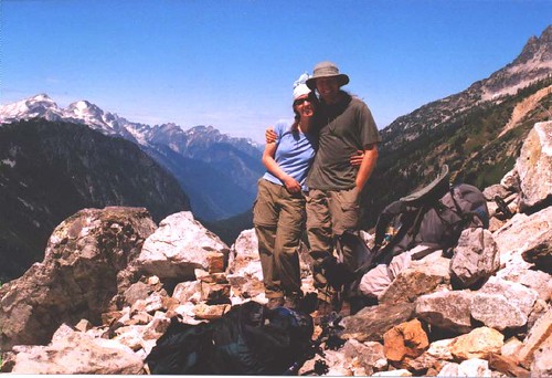 After about an hour, we reached the pass, which was well worth all of the trouble. The views both to the north and the south were stunning. To the north, we could see the Picketts, and to the south we had a very clear view of the aptly-named Sawtooth range. There was still a little snow in the pass, but the trail was on the slope about 20 yards above and was completely clear. We dawdled at the top for a while, taking pictures and gaping at the view. Eventually it was time to say farewell to Thunder Creek and to head down into the Park Creek drainage.
 The views on this side were equally spectacular, and I found myself wishing we had an extra day to hang out up here and explore the basin. But we had to press on down to the main channel of Park Creek, which drains the south face of the impressive Mt. Buckner. This part of the trail was even steeper than the climb up, and it went on for longer. We were glad we didn't have to climb up anything like this for the rest of the trip. On the way down, we finally saw our first (and only) bear of the trip. Coming down a steep section through a thicket of alder, we heard something rustling in the trees below us. We paused, and I noticed a big, brown shape lumbering just off the trail. We started yelling at it, and although it took its time, it slowly ambled away from the trail. We did have a nervous moment as the next switchback angled us back toward the bear, but luckily we didn't see any more of it.
The trail finally leveled off after a couple miles, and we were in 5-Mile camp before we knew it. Our first priority on arriving in camp was to wash off in the creek, which we hadn't had the opportunity to do the night before. Unfortunately, this camp was home to legions of biting flies. Although we had encountered them throughout the day on the trail, we hadn't found them very threatening because they were generally pretty slow-witted and easy to swat, and they didn't bite often. However, as soon we was standing in the creek with all of our flesh exposed, splashing off with glacier-fed water, they suddenly become emboldened and descended on us. Needless to say, I didn't wash off very thoroughly. We quickly covered ourselves in long sleeve shirts and started to set up camp. After dinner (curried lentils and rice, a consistent favorite), a deer wandered into camp. It meandered around the campsite, keeping a respectful distance, but not really paying us much mind. After it started nosing around the sump hole where we washed our dinner dishes, I stood up to shoo it off. It seemed startled at first, as if it hadn't realized we were there until then. But then it sauntered off, taking its time before crossing the creek and heading up the trail. As the sun went down, the flies became less active. They were, however, replaced by mosquitoes, so we were happy to retreat to the tent after a (well-earned but sadly not very tasty) dessert of vanilla pudding.
Next: teenagers, pot roast, and a forest fire

posted by Mark at 8:10 AM
![]()

3 Comments:
I'm excited for the next installment! This sounds like it was a wonderful trip.
What water purification system do you use?
8/08/2006 3:52 PM
This comment has been removed by a blog administrator.
8/09/2006 8:09 AM
Hey Beau,
We use a Sweetwater filter. It's been really reliable and it pumps the water relatively quickly, especially compared to some other pumps I've used. Here's a link to some product info and a picture (our's is white, but otherwise looks the same):
http://www.msrcorp.com/filters/sweet_microfilter.asp
8/09/2006 8:10 AM
Post a Comment
<< Home